ATELJE PRELOVŠEK
architecture_urbanism_interior design
projects studio info news contact
architecture urbanism interior design
<<< back to list of urbanism
-------------------------------------------------------------------------------- BUSINESS AND TRADE ZONE TOJNICE
Urban design for reuse and regeneration of Vrhnika dump area, Slovenia
Project description: Brown field In
Vrhnika between the highway and north river bank of Ljubljanica has
been a dump place for the industrial rubbish. Investor Ceeref decided
to build a new business and trade zone in the flat area near highway
and solar power plant on the artificial hill that consist of industrial
rubbish. Our proposal of urban design in 3 variants was basis for the
new urban regulation that investor wanted to negotiate with the
municipality. The aim of the proposed project was to regenerate the
area with the Eco-industrial park solution that would be able to
develop "green business", advertisement and development of waste
recycling, lower energy consumption of the district and advertisement
of new business that uses ecological technologies.
Location: Vrhnika, Slovenia
Size of project area: 44.012 sqm
Size of gross building surface: 21.855 sqm- VAR 1, 28.065 sqm- VAR 2, 23.210 sqm- VAR 3
Project phase: preliminary study (IR- idejna rešitev)
Year of the project: 2010
State of the project: on hold
Client and investor: CEEREF Projekt Pot na Tojnice, d.o.o.
Authors: Eva Prelovšek Niemelä, Tina Filjak Juračič, Aarne Niemelä

3 proposed solutions
Historical background
Vrhnika
has been historically know as district of cargo transit and storage of
merchant fright. It had been important place because river Ljubljanica
was navigable from Vrhnika onward and had represented a faster means of
freight. There is an archaeological site in vicinity of the new Tojnice
district which shows ancient Roman harbour Navportus.

Starting points
In vicinity of the new Tojnice area there are following morphological structures:
1. Archaeological site- Roman harbour, with longitudinal building structures formed around the inner courtyard.
2. Storehouses from 18. century with longitudinal floor plans
3. Groups of family houses that are build in typical Slovene suburban outline.
4. River meanders of Ljubljanica river and Tojnice brook that are typical for Barje flatlands.
5. New solar power plant on the dump hill that faces south and will influence the identity of the surroundings.

Ways of sustainable urban planning
- To create clear and
positive identity of building groups that brings better recognition and
attractiveness of the area and therefore keeps district vital for next
generations.
- Regeneration of the area from dump place into spaces with new working places.
- Advertisement of new sustainable technologies and firms that are dealing with it.
- Own production of energy from renewable resources.
- Low energy consumption (and low cost application).
- Flexibility of building structures, that enables easy renewal in the future.
- To create new local center also with additional activities for recreation, education, entertainment and catering.
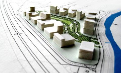
VARIANT 1

New
district is formed around common center: green meander that consists of
parking places, rows of trees and ponds with plant sewage treatment
system. Buildings around the center are formed in longitudinal way,
similar like traditional storehouses of Vrhnika. Green center is
attractive for customers, visitors and employed people. It attracts
pedestrian and bike traffic, cleans the air and sewage. There is
minimal amount of streets in the district (one outer circular street
for cargo and delivery and short perpendicular connections) which
prevents further degradation of the area.
New Tojnice district is reminiscent of harbour with green meanders.
Vrhnika once was a harbour therefore here, metaphorically, district is
rediscovering a forgotten identity.


Situation plan- Variant 1

Sections- Variant 1
VARIANT 2
Variant
2 consists of joined building volumes form Variant 1. It therefore
consists of bigger buildings and therefore enables less mixed
activities. Bigger workshops, industry and shops would also need to get
more parking places organized outside of the area.


Situation plan- Variant 2

Sections- Variant 2
VARIANT 3
Variant
3 is made of buildings joined together into one long facade towards the
highway. The whole logistics is organized along the highway border,
while customer's and employed people's parking is organized on the
other side in the green meanders. Parking lots are placed under the
tree rows in the meanders while other green areas can be organized as park or
children's playgrounds. This building type allows to form a single
shopping mall, joined building of bigger firms or separated small
business units.


Situation plan- Variant 3

Sections- Variant 3
--------------------------------------------------------------------------------
<<< back to list of urbanism